Raster und Netz
Brasilia – ein Pilotplan der Moderne und seine Umnutzung
Grid and Net Structures
Brasilia – a Pilot Plan of Modernity and its Alternative Uses
Abstract (master thesis/Art in Context/Universität der Künste, Berlin/2010)
BELVEDER, 2010, Foto Installation, Größe variabel
This artistic research (text and photography) is an approach to alternative tactics of using the city space of Brasilia.
Brasilia is the city I grew up in. Since I don’t live there anymore, I am an observer of a familiar and at the same time unknown, strange distant environment. Starting point of my work is therefore the dealing with different perspectives from which I perceive the city - in situ, remembered out of distance or virtually through Google Earth. The research, which is accompanied by a historical and formal contextualization of Brasilia, reflects what the city space sets in advance, what it offers and what it doesn’t enable (what/who it forgets).
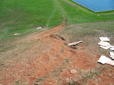
Brasilia was developed on a drawing board; it is based on a coordinate system of a grid structure and on an efficient traffic network. But Brasilia’s inhabitants and workers use the grid-principle of the Car City in ways different from those planned. This becomes apparent while observing the paths crossing the large ornamental grass lawns of Brasilia’s Monumental Axis. These paths show that the given infrastructure is not useful or efficient for everybody. As a consequence the grid as a strictly geometrical pattern is loosened up. Through new connecting paths the grid turns into a net structure. As a more organic pattern, the net structure returns to a practical form of the urban environment, through which the Planned City is remodeled and therefore appropriated. Walking in a city for car owners alludes to economical and social aspects of the urban space. Both, formal and rational, Brasilia’s plan claimed a social function; the used city is nonetheless fundamentally elitist. The social segregation, which dates from colonial behavior patterns, continues in the urban space. The left visible path-traces refer to the impossibilities of the planning and possibilities of its alternative uses.
Silvia Marzall
www.silvia-marzall.info